Filling the research gaps - why do maps matter?
19 APRIL 2016
Elimination of artemisinin resistant parasites requires the identification of geographical areas with low transmission and intense selection pressure, locations seen as potential hot spots for new outbreaks of drug resistant malaria.
Spatial modelling to estimate the geographic distribution of malaria endemicity and antimalarial drug resistance has become an increasingly active research area in recent years. However, while some studies have used computer simulation of statistical models to generate continuous predictive maps, there has been little emphasis on how these maps could be used to improve data collection and provide evidence for policy makers and practitioners to support more targeted interventions.
The application of modelling tools that provide geospatial information can support malaria researchers and policy makers to ensure resources are efficiently deployed and rapid response to newly emerging resistance. Since 2013, WWARN scientists have been working with partners including the Malaria Atlas Project (MAP) and the London School of Hygiene & Tropical Medicine to develop an approach referred to as 'smart surveillance'.
Elimination of artemisinin resistant parasites requires the identification of geographical areas with low transmission and intense selection pressure, locations seen as potential hot spots for new outbreaks of drug resistant malaria. Such geospatial information is crucial to mobilise resources to eliminate resistant parasites and thereby reduce the risk of their spread to other localities.
Smart surveillance is being used to develop a geospatial map of antimalarial drug resistance in endemic areas such as the Greater Mekong sub-region, and in important countries including Myanmar. In 2015, WWARN’s mathematical modellers worked with the research teams in Asia to develop predictive map models. Their modelling results suggest that the prevalence of a certain gene mutation associated with drug resistance in the malaria parasite population known as K13 could be as high as ten per cent in areas to the North and East of Myanmar. This close to real-time information on malaria drug resistance is valuable to help predict where the resistant parasites might emerge or spread next. The data could also be used to inform patient treatment intervention strategies used by national health programmes and non-governmental organisations.
In Africa, resistance to chloroquine (CQ) and sulphadoxine-pyrimethamine (SP) led the World Health Organization (WHO) to recommend changes in national drug policies. The time between policy changes and their implementation profoundly affects patient outcomes. In collaboration with ACTwatch, our team developed a modelling approach to quantify the treatment changes in CQ and SP both from 1999-2011, and also after the change in policy in multiple countries across Africa. If artemisinin resistance is confirmed in Africa these methodologies and maps will be valuable to help estimate actual drug use and its impact on changes in drug efficacy.
In another project, the changing prevalence of the dhps540E mutation in sub-Saharan Africa were mapped to allow prediction of space-time trends in the parasite resistance to SP. The maps provide probability distributions of resistance prevalence in places where no data are available as well as insight on the spread of resistance in a way that the data alone do not allow. These mapping approaches provide us with visual data evidence that can be used to support the malaria policy making and research community to develop informed, targeted and cost-effective patient treatment strategies.
In the future, if genomes of parasites from specific sites were analysed, it would also be possible to determine whether the resistance parasites have spread from a few foci or emerged independently in different areas under study. At the same time, recommended therapeutic, preventive, and vector control measures could be targeted at those areas free of resistant parasites.
The smart surveillance methodology is a general one, and could be applied to other genetic markers correlated with resistance to ACT partner drugs. Moreover, this approach can provide a first step toward wider application of modelling approaches to support and extend government efforts in malaria control.
To complement these mathematical modelling endeavours, WWARN teams have developed a number of data visualisation tools to help monitor the spread of drug resistance genes in parasites over time and space. These include three molecular surveyors:
- The K13 Surveyor – a summary of the prevalence of mutations in a particular parasite gene called K13, believed to be a major marker of artemisinin resistance in Plasmodium falciparum.
- The pfmdr1 & pfcrt Surveyor – a summary of mutations in two falciparum proteins, the Chloroquine Resistance Transporter (PfCRT) and the multi-drug resistance gene (PfMDR1), that have a role in resistance to many antimalarials, including chloroquine, amodiaquine, lumefantrine and mefloquine.
- The dhfr & dhps Surveyor – a summary of the mutations in two falciparum enzymes responsible for resistance to pyrimethamine and sulfadoxine, respectively.
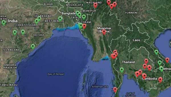
The WWARN Explorer analyses patient data from the WWARN repository, looking at phenotypic resistance through the analysis of clinical data. It enables researchers to visualise the results of trials and identify opportunities for new clinical trials, thereby filling the gaps in data that are needed and providing opportunities to extend the evidence base.
The Antimalarial Quality Surveyor summarises reports of poor quality drugs used to treat patients with malaria in endemic areas. This tool helps advocate for more commitment, resources and research to investigate the important issue of substandard and counterfeit drugs, and has the potential to be extended to include a range of different medicines.
WWARN is interested in developing our different map-based approaches to support policy makers, researchers and donors. We are keen to develop more partnerships - if you have an idea on how we could provide you with more practical maps and models to enhance your work, or form a new partnership, please contact us via info@wwarn.org to discuss this further.